
|
Harrison Eiteljorg, II
Using AutoCAD to make surfaces, not just lines, is essential to the model-making process. Without surfaces, the program cannot make a hidden-line drawing because only surfaces, whether explicitly or implicitly defined, hide objects that are behind them. Without surfaces, lines can exist in three-dimensional space correctly, but 3D views can be very confusing. For instance, here are two views of the same corner of the older propylon, one shown as a hidden-line drawing and one shown as a wire-frame drawing. The difference is striking.
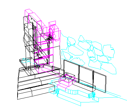
Fig. 1 - The forecourt of the older propylon on the Athenian Acropolis, wire-frame drawing.
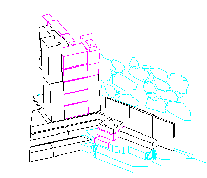
Fig. 2 - The forecourt of the older propylon on the Athenian Acropolis, hidden-line drawing.
An important problem can arise with CAD surfaces made to represent irregular objects. The more irregular the object, the more likely it is that modeling the surface will be done with a group of small surfaces, each being one facet of the whole, unified surface (with the edges between facets normally suppressed for display). Thus a block defined by a series of points around its perimeter, such as these two very irregular blocks in the Mycenaean wall near the older propylon, will consist of a group of surfaces defined by survey points taken around their perimeters.
Figure 3 shows the outlines of the blocks and the individual surface facets modeled in two different ways. Both versions of the modeled blocks use the same data points, but the facets have been modeled very differently.
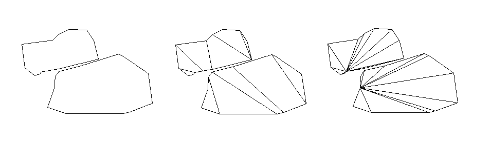
Fig. 3 - Two blocks from the Mycenaean wall shown in three different ways. The drawing to the left shows the outlines of the blocks, as they appear in Fig. 2, though from a slightly different point of view (the far right-hand block and the block immediately above it in Fig. 2). In the center are the same two blocks, with modeling facets shown. At the right are the same blocks again, with different modeling facets.
The potential problem with joining facets to make a unified larger surface lies in the subtle differences created when the individual facets of the unified surface are modeled differently. Taking just the two blocks from the Mycenaean wall and showing them modeled in two ways -- and rendered to show the differences more visually -- illustrates how much difference there can be between two models of the same blocks based on the same points but using differently modeled facets.
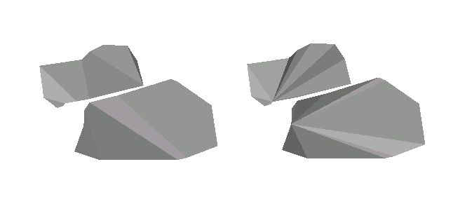
Fig. 4 - The same two blocks, modeled as above in Fig. 3, shown in simple rendered views.
More extreme differences can exist, and a hypothetical block, shown as an outline and two different models, first showing the facets and then rendered to display the differences starkly, shows such an extreme case.
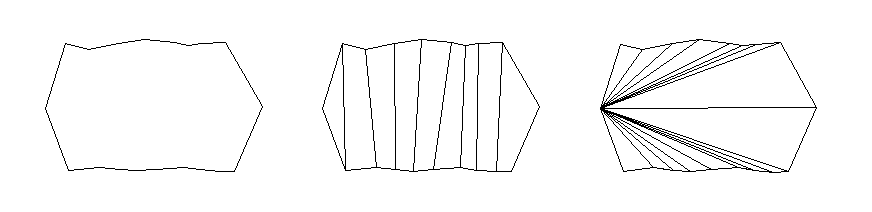
Fig. 5 - A hypothetical block, shown in outline view (left) and two differently faceted models.
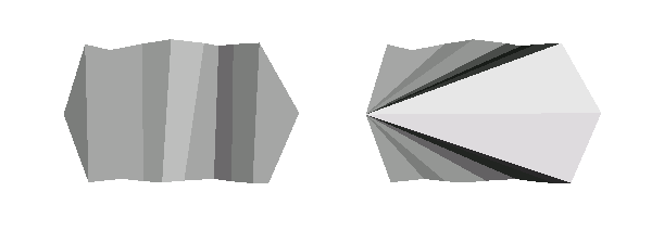
Fig. 6 - Simple renderings of the same two models of the hypothetical block in Fig. 5.
The issue here arises only with complex and irregular blocks. Simple, regular blocks present simple, regular surfaces, but boulders and polygonal blocks may not. When modeling them, CAD users must be very careful to consider the points surveyed and the ways they are connected to one another to create the many individual surface facets that combine to make the whole block. The data will remain available via the model, since each point has fully specified coordinates, but the modeling process can drastically alter the appearance; so it must be carried out with care and planning.
In addition, the number of points surveyed to define the shape of an irregular block must be carefully considered, as must the actual points chosen. (The problem of deciding how many points to survey has been discussed in the CSA CAD Guide for Archaeologists and Architectural Historians under the term data density; in the GIS world, the similar issue is called generalization.) Surveying more points permits better matches between real objects and their models, but surveying more points also adds time and expense. The gain in model fidelity to the real world is often inadequate to justify the added cost and modeling complexity required by surveying too many points. Some compromise between model completeness and the number of points surveyed must be found, since there is virtually no number of points sufficient to define a very rough and irregular stone such of some of those in the forecourt of the older propylon.
The choice of points to be surveyed is equally important. The examples here, for instance, have included no points in the interiors of the blocks but only points on the perimeters. Such choices would be difficult to defend with most irregular blocks, but exactly which points on the face of a block should be surveyed must be decided with care, not chosen haphazardly.
It is the responsibility of the scholar in charge of the modeling process to make such decisions self-consciously - and to include information about such decisions in the documentation of the project.
-- Harrison Eiteljorg, II
To send comments or questions to the author, please see our email contacts page.
For other Newsletter articles concerning applications of CAD modeling in archaeology and architectural history or the use of electronic media in the humanities, consult the Subject index.
Next Article: Measuring Ancient Structures
Table of Contents for the Fall, 2002 issue of the CSA Newsletter (Vol. XV, no. 2)
 Table of Contents for all CSA
Newsletter issues on the Web
Table of Contents for all CSA
Newsletter issues on the Web
| CSA Home Page |