
|
Paul Blomerus and Alexandra Lesk
(See email contacts page for the author's email address.)
The model of the Erechtheion we created for the first article in this series ("Using AutoCAD to Construct a 4D Block-by-Block Model of the Erechtheion on the Akropolis at Athens, I: Modeling the Erechtheion in Four Dimensions," CSA Newsletter, XX.2; Fall, 2007) relied on detailed information from paintings, drawings and descriptions by early travellers collected as part of Dr. Alexandra Lesk's doctoral research1 to create a 4D model of the Erechtheion. From this model, we produced an animation of the building's phases through time recorded as a movie; however, we found that, while interesting and eye-catching, the movie was a rather limited and unidirectional method of interacting with the output of the research. We wanted to create something much more interactive that would allow users to interrogate the evidence for a particular reconstruction and view it for themselves using an easy and intuitive interface. By equipping a 3D virtual-reality representation of the Erechtheion reconstruction with hyperlinks to the evidence for that reconstruction, we were able to create such an interface and have called it an "interactive 3D database". If the time dimension is added, it becomes a 4D database.
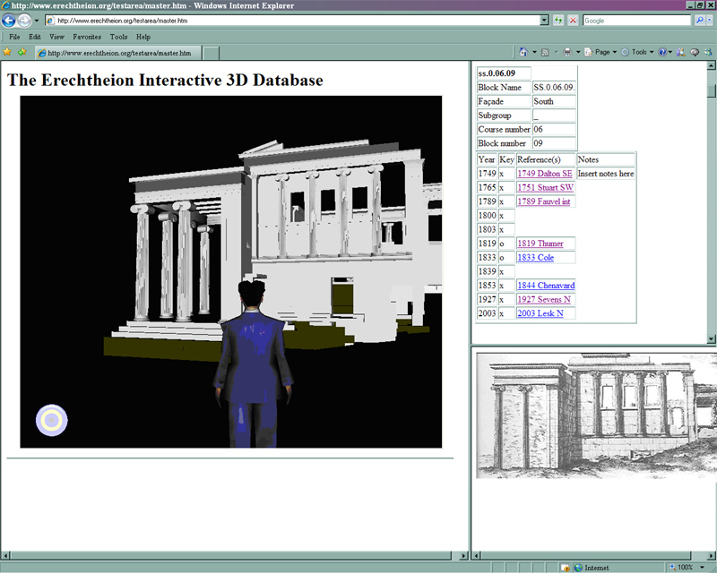
Fig. 1. The Erechtheion Interactive 3D Database.
In this article we propose a method whereby data about a particular object (be it a date of creation, contemporary description, photograph, drawing, academic citation, object bibliography, etc.) is linked directly to the representation of that object in a 3D virtual-reality world using hyperlinks. By changing the attributes of the objects (such as appearance, colour or texture) based on the information in the database through the method proposed in the second article in the series by the authors ("Using AutoCAD to Construct a 4D Block-by-Block Model of the Erechtheion on the Akropolis at Athens, II: Connecting a Database to an AutoCAD Model," CSA Newsletter, XX.3; Winter, 2008), a rich, interactive experience is created for the user in which information about objects of interest is presented in its full spatial and temporal context. The result is informative for scholars attempting to interact with material and is likely to lead to improved scholarly dialogue, which, as we will show later in Section 6, can even take place in the virtual world itself.
In Section 5 of the article, we describe how this method of creating an interactive 3D database can also be applied to archaeological excavations as well as architectural research projects to enable a community of scholars to engage in a dialogue with all manner of spatial and other relevant data, no matter where the scholars are in the world, and in a much more meaningful way than the usual flat, 2-dimensional, paper or electronic interfaces. Participating scholars need nothing more than a web browser, and what is more, all this can be accomplished very simply and cost-effectively by small extensions to commonly-used CAD and database software. Though we begin by describing everything in three dimensions, in Section 6, we will show how to extend the method to be fully four-dimensional by adding the time vector to the interactive 3D database.
Archaeological or historic architecture projects often employ third party providers such as Learning Sites, CERHAS, Digitale Archäologie or the Foundation for the Helenic World to create 3D reconstructions of their projects. These professionals can produce a 3D model of reconstructed buildings in consultation with the project archaeologists and architects. From this model, full-colour rendered perspective views can be created. Sometimes, budget permitting, first person "flythrough" movies can be created or even virtual-reality worlds for users to walk around in.
The results of these commercially created 3D reconstructions, while pleasing to the eye and important contributions to public access, are often unsatisfactory to serious scholars. This is because it is difficult to view or critique the logic and sources for a particular reconstruction. In addition, scholars will need to wait weeks, possibly even months, before they can study the output to validate a particular hypothesis. Finally, these professional reconstructions or digital models are costly to create and often beyond the budget of the average research project. The interactive 3D database and the method we propose here to create it overcome these problems by presenting the evidence for a particular reconstruction in an extremely logical and accessible way, and, as we will show later, within a budget affordable to almost everyone.
The problem we faced on the Erechtheion project is one that many research projects face. We had a large volume of data about the building that was inaccessible and difficult to visualise. Objects (construction blocks, walls, finds, etc.) usually have at least some 3D information (a location and dimensions) and temporal information (a date) in addition to other interpretative information stored in one or many electronic databases. The 3D information is sometimes modelled using CAD software stored in one form of database while the rest of the information is stored in another, but very rarely are all the data sources linked together and presented in a manner that makes them accessible to all project researchers in a meaningful way. We believe there is a far-reaching need for a robust, low-cost method to create easily and quickly accessible interactive 3D spaces where communities of scholars can interact with, discuss and critique the full range of material they are studying in its proper spatial context. We believe we have created a method for setting up these interactive 3D databases that meets these requirements and have pioneered its use on the reconstruction of the Erechtheion.
To launch the interactive 3D database, users need only click on a link in their internet browsers. The first thing they see is a 3D perspective view of the Erechtheion viewed from the point of view of their scale avatar (a representation of the user in the virtual-reality space of the interactive 3D database). The building they see is a digital representation of the Erechtheion as it was at a particular point in time.
To navigate around the virtual-reality Erechtheion, users can direct their avatars to walk or fly using the mouse or cursor keys. As can be seen in figure 2, the perspective view automatically updates to take account of movement. Walking is useful as it aids comprehension of the flow of foot traffic between buildings or rooms, while flying is useful to examine inaccessible areas of the building (without the need for scaffolding!). The usual CAD manipulations like pan or 3D-orbit are also available, but with a human-scale avatar, most users will find walking or flying the most intuitive and useful ways to navigate the virtual-reality world.
Fig. 2 – Video showing navigation of the 3D virtual-reality world of the Erechtheion.
(If no video file plays, click here to download the file and play it on your computer with
Microsoft® Windows Media Player or an appropriate alternate.)
If users encounter an object they wish to learn more about, such as a particular block in the building, they simply have to move the mouse pointer over it and the name of the object or the object ID will appear. If they click on it, a window to the right of the virtual-reality world is filled by all the information about the object they have just clicked on, downloaded from the object database. In the case of the Erechtheion interactive 3D database, this window contains information about the history of the block the user has clicked on with references to the historic drawings or pictures in which it is visible. The information downloaded can also include hyperlinks to further information, for instance pictures, notes or links to articles and other project web pages. In our case, clicking on a reference to a drawing or painting brings up a small image of that drawing or painting in the bottom right corner of the screen; the image can be enlarged for closer examination. Figure 3 shows a screenshot of the Erechtheion interactive 3D database in use.
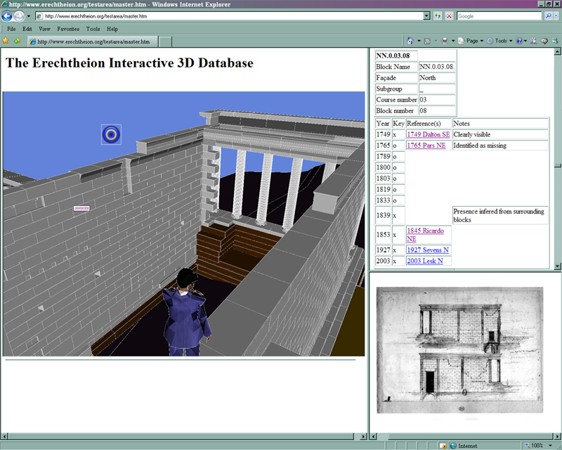
Fig. 3 – The Erechtheion interactive 3D database in use.
So what does this achieve? The presentation of the 3D geometry and database information in a format that is accessible by users with only basic computing skills and no specialist database or CAD software is a massive leap forward. In the first instance, researchers are able quickly to verify the completeness of the data contained in the records. Once basic checks have been completed, users can begin to validate any theories about the history of the building under consideration, including reviewing the primary evidence and evaluating the judgments that have been made about what particular historic images of the Erechtheion show or don't show. The user can quickly navigate to the same vantage point in the virtual-reality world from which the historic traveler made his painting or drawing to assist with this comparison.
In our case, the research team is relatively small (consisting only of the authors) and live in the same house, so highlighting a problem or voicing dissent about a particular theory for the reconstruction involves at worst simply calling downstairs. But for larger projects, we have envisaged a means for secondary users to interact with the scholars who prepared the reconstruction in the first place, making the database fully two-way interactive.
What follows in Section 4 is a detailed description of how we set up the interactive 3D database of the Erechtheion that we hope will serve as an instruction manual for others. If you aren't interested in the "how?" and want to move on to more of the "so what?", skip ahead to section 5 now.
The data structure that we used is shown in figure 4 and is an extension of the one proposed in the second article in the series. We added a third leg to the data structure in the form of the interactive 3D database itself, the two core constituents of which are a) the 3D virtual-reality world (exported from the CAD model) and b) an HTML download of the object database.
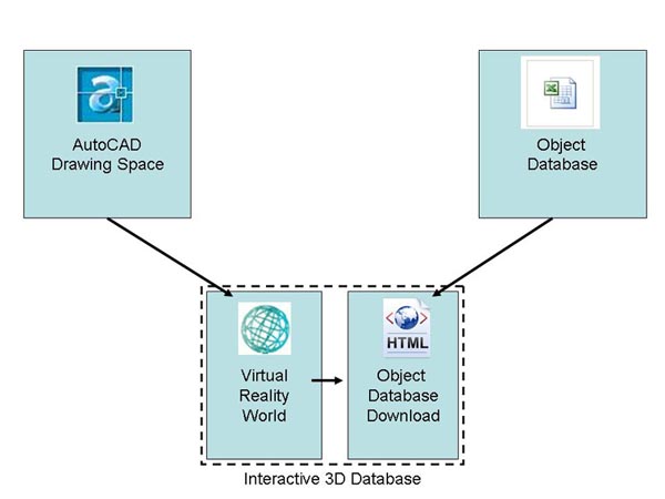
Fig. 4 – Recommended data structure.
This data structure ensures that the master data about spatial information is contained in the CAD model and the master data about all other object information is held in the object database. The interactive 3D database is really a "reference only" copy of these two sets of master data and may represent only one particular state or sub-section of the data useful for a specific study purpose. Multiple interactive 3D databases can be created quickly from the same master data, but the original data are held securely within the CAD model and the object database itself. The file formats we have chosen also have particular advantages for archiving in that they do not rely an a particular proprietary CAD or database format.
The file format we used for the 3D virtual-reality world is Virtual Reality Modeling Language (VRML).2 The VRML format creates sharp, accurate, and responsive 3D representations that support hyperlinks, making it perfect for our purposes. The only drawback is the file format is unencrypted, so if you want to make your interactive 3D database accessible via the internet, you can not easily protect your 3D geometry (other than through asserting a copyright that is).
To generate the 3D virtual-reality world, the geometry needed to be exported from the CAD model. But before we exported the geometry, we needed to add hyperlinks to each of the objects in the CAD model. These hyperlinks form the basis of the interactivity in the database, so each object needs to carry a hyperlink to the information about it in the object database. Since we were using AutoCAD, we could use the AutoCAD HYPERLINK command, but to speed things up, we wrote a simple Visual-Basic® macro for AutoCAD. Recall that the convention we have used throughout this series of articles has been to assign each object to an AutoCAD layer with the unique object ID as a layer name. Therefore, all the macro had to do was to take each object in the drawing one by one, determine its layer name and then add a hyperlink with that name. The process took less than a minute to complete for the 1,000+ blocks in the entire Erechtheion model. The result is that when hovering over a linked object, the AutoCAD cross-hairs change to a small globe with a chain, and the display name (which our macro had set to the object ID) pops up in a rectangle. Figure 5 shows an example. This feature is actually quite useful for checking to be sure that each object has been assigned to a correctly named layer; the user can move the cursor rapidly down a line of blocks and check that the display name changes to the expected object ID for each. Note that if X-Refs are used for sub-models in AutoCAD we found that the sub-models had to be bound to the master before applying hyperlinks or exporting the data to the VRML file.
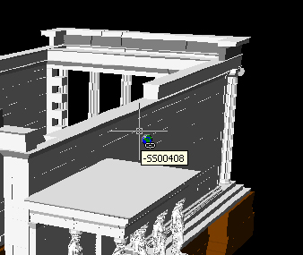
Fig. 5 – Hyperlinked AutoCAD model screenshot.
To perform the export of the CAD data to the VRML 3D virtual-reality world we used an inexpensive but effective add-on for AutoCAD called VRMLOut by Xanadu Software.3 Once installed, exporting AutoCAD geometry is as simple as clicking on the "Export" button in the VRMLOut toolbar.
The fact that you can select visible objects in VRMLOut makes handling multiple scenarios or time periods relatively easy. Using the method described in the second article in the series, we simply had to drive the AutoCAD model to the desired state using the linked object database and then export the visible objects in their desired state to a new VRML file using VRMLOut. Of course, if you want to export everything, then the "select All" function is still available.
The export process takes a few minutes for highly complex models; the only problems we encountered were with exporting complex multi-faceted polygonal surfaces representing sculptures such as the Erechtheion maidens. For these we created a specific VRML file for the maidens and then used a special feature of the VRML language called in-lining to import the maidens into the master model of the Erechtheion.
VRMLOut saves the virtual-reality world as a file with a .wrl extension in the location of your choice. We found that it was worthwhile at this stage to browse the virtual-reality world by launching it in the standalone VRML browser to check that the geometry was as we expected it. We found that simplifying the VRML file using Chisel (free software for VRML processing and optimisation by Trapezium Development LLC) resulted in a VRML file size reduction of more than 50% and improved the speed of access for the virtual-reality world significantly.
The method we have described here uses AutoCAD, but this is not essential. Many 3D authoring tools import CAD geometry from a number of software packages and can output VRML geometry, so creating a virtual-reality world for your interactive 3D database from you CAD model should not be too hard. The challenge will be making sure that hyperlinks are supported.
The principle of the interactive 3D database requires that pertinent information about the objects be made available at the click of mouse. To enable this, the object data need to be downloaded from the object database into an easily accessible file format. We chose to export the data into an HTML file with a separate bookmarked section for the information about each object. The file structure was chosen so that the object database file can remain open in the window to the side of the interactive 3D database user's screen. Then, when a user clicks on an object, the hyperlink will cause the file to scroll to the corresponding bookmark and display the information about that object
Our Erechtheion database was stored in a Microsoft Excel spreadsheet;4 so creating the desired HTML file was as easy as creating a macro that read the line of information for each object in the database and then output it into a text file with suitable HTML tags to create the index bookmark and any formatting for presentation.
Any further links to additional relevant material about the object, for example images of the paintings or drawings or other electronic documents, need to be contained in the database in a usable hyperlink format. We found the easiest way to achieve this was to create a special field in the database containing the exact hyperlink text required in HTML format, that way, when the contents of the database were downloaded to the HTML object database, the web browser correctly interpreted the hyperlink as it was intended.
Once created, the object database download in HTML is viewable in an internet browser. We saved the HTML file in an accessible file folder alongside the VRML virtual-reality world file (.wrl). The task of creating object database downloads can be automated so that an up-to-date copy of the object database is downloaded for use by the interactive 3D database at the press of a button, at regular time intervals or upon opening or closing the object database file.
The remaining task was to connect the 3D virtual-reality world (exported from the CAD model) and the HTML download of the object database to create the interactive 3D database.
By default, the hyperlinks in a VRML world viewed through the VRML browser will launch a new instance of the internet browser with the destination of the hyperlink contained in it. So as along as the VRML file for the 3D virtual-reality world and the HTML download of the object database are stored in the same place, the hyperlinks should already connect the two files. But this can get cluttered because a) each click creates a new instance of the database in its own web browser and b) the new instance of the web browser obscures the view of the 3D virtual-reality world. The simple improvement we made to fix this was to use HTML frames so that users could launch the interactive 3D database in a single web browser instance. The 3D virtual-reality world was embedded in the largest frame on the left, and the download of the object database was called up in the smaller frame to its right. To get this to work, we needed to make sure the hyperlinks attached to the objects pointed to the correct frame and to the correct bookmark in the html object database extract file. It helps to know in advance the file names, frame names and file storage structure you are going to use so that when the hyperlinks are added in the CAD model they can be given the correct attributes, but because the VRML files are simple text, the "find and replace" function in a text editor can be used to amend the hyperlinks so they point to the correct file, frame and bookmark if you change your mind.
The basic HTML and VRML code for a simple web page interface for the interactive 3D database is shown in figure 6.
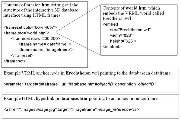
Fig. 6 – The code required for the interactive 3D database with frames.
The interactive 3D database can be used on a single computer or loaded onto an intranet or internet location. The key constituents are the web-page interface containing the two frames, the .wrl file containing the VRML 3D virtual-reality world and the HTML object database file. Extra items referenced from within the HTML database, such as images or documents, need to be uploaded to an accessible folder as well.
The Erechtheion model takes a few seconds to load in the VRML browser because of its size, longer if over a slow internet connection. Once loaded, movement around the virtual-reality world is acceptably smooth, though clearly this is not a computer game. Because each block in the building has been modelled as a separate polygon, the VRML browser has to resolve each one independently as the user moves around. We found that setting edges to silhouette in the graphics settings of the browser helped to clearly pick out the outline of each block as is illustrated in figure 7.
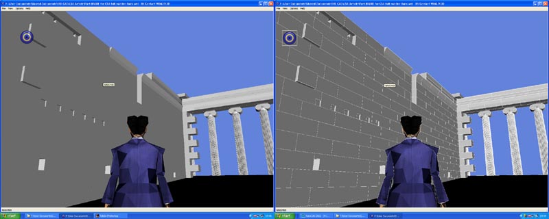
Fig. 7 – North wall of the Erechtheion with and without silhouette.
Once loaded, the user is free to explore. We found navigating with the cursor keys on the keyboard to be most effective, leaving the mouse free to click on objects to bring up the object data.
5. Other Applications of the Interactive 3D Database
Interactive 3D databases and the method we have proposed here for their creation have widespread potential application in archaeological field projects and historical architecture. Almost any project where CAD is being used to record spatial information about objects that also have associated interpretive information stored elsewhere in a database is a potential application. Here we expand on two likely applications for archaeology.
The archaeological site architect could easily provide an interactive 3D database of the walls and other architectural features surveyed in the field for others on the project to use. Even if the surveying method is only capturing 2D information, the 3D virtual-reality experience provided by the interactive 3D database is still helpful.
When the method is applied to architectural survey on an archaeological site, each object surveyed is assigned a unique object ID (conventionally assigned sequentially in a system predetermined by the project director). The excavators can then enter interpretive information about any architectural feature such as date, the building to which it belongs, or the occupation phase to which it corresponds. This architecture database, when properly linked to the CAD model, as described in the second article in this series, can be used to change the visibility, colours, linetypes, or textures of the objects in the CAD model. If the method described here is also followed, excavators (and others) can then browse the survey data in an interactive 3D database with a simple web browser.
If the site architects attempt any 3D reconstructions, they can be included in both parts of the interactive 3D database. Information from satellite, aerial or balloon photography can also be integrated as backgrounds to help users find their way around the virtual-reality representation of the site. If 3D laser scans, with or without integrated photogrammetry, are available of the site, they can also be exported into the virtual-reality format so that those studying the site can use their avatar to "walk" through the site with laser scan information and CAD information displayed (suitably colour coded based on the desires of the user). A click on any architectural feature in such an interactive 3D database brings up all the data from the architecture database concerning that object.
Such a system would make surveyed data much more accessible to everyone working on a project without the need for them to have CAD software on their computers or to know how to use CAD software. Updated versions could be uploaded periodically to reflect new information as it is captured by the architects on site.
Excavators should not feel left out either. We have experimented with the application of the interactive 3D database concept to excavations. In these trials, the excavation units, artifacts and features have been included in the data structure, as shown in figure 8.
The excavation units have been turned into translucent polyhedrae using the opening and closing coordinates. These excavation unit polyhedrae have been colour coded based on the date from the pottery evidence. Small finds have been plotted with a link to an extract from the small finds database. Clicking on the excavation unit brings up the excavation notebook entry for that excavation unit.
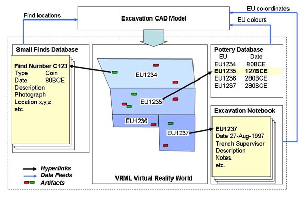
Fig. 8 – Data structure for the excavation interactive 3D database.
The primary users of such an excavation interactive 3D database would be the trench supervisors and field director, who would use it to decide on the chronological sequence. They would be able to cross-check for mistakes made in coordinate entry and compile Harris Matrix diagrammes showing the relationship between excavation units. But by making the interactive 3D database available online, experts from around the world could be invited effectively to re-dig the excavated material in a virtual-reality environment. The project team could enhance the experience with links to digital photographs taken during the excavation and of relevant pottery fragments or small finds used for dating. This method makes possible a near-real-time, high quality scholarly dialogue about the interpretation of the evidence.
The excavation interactive 3D database can also act as a spatial index for the excavation notebooks which are conventionally stored by site grid reference and year of excavation. No longer will researchers spend hours trying to locate the excavation notes from a particular trench; with the excavation interactive 3D database, they can quickly navigate to the area of the site they are interested in and then hyperlink to the relevant notebook together with all the project data about that trench.
Virtual-reality excavation interfaces have been attempted before. Eileen Vote and a team from Brown University created a fully immersive virtual-reality environment called ARCHAVE complete with data glove and stereoscopic vision helmet. They used it to view the distribution of lamp finds in their original 3D excavation context around the Great Temple of Petra.5 The FOVEA project have created a similar virtual excavation environment for paleo-anthropological cave archaeology.6
The main advantage of the system proposed here is that it is cheap and easy to implement. The tools required are probably already in use by the excavation team and no special software (bar a free VRML browser download) is required to use it.
The interactive 3D database we created for the Erechtheion as described in Section 4 was very simple in its functionality. In this section, we describe some enhancements and extensions to the method which improve the utility of the database format.
We have encountered very few examples of 4D interactivity in virtual heritage. One example is the Nu.M.E project that attempted to reconstruct historic Bologna.7 More recently, the Digital Karnak Project has created an interactive time machine that permits users to trace the development of the temple complex from its earliest phase in the Middle Kingdom (1950 BCE) through the Greco-Roman Period (31 BCE).
To add the fourth dimension to the interactive 3D database of the Erechtheion, we created a separate virtual-reality world for each step in the time series. This is not as onerous a task as it would sound. Because each time step in the CAD model exists as an AutoCAD layer state, it was simply a matter of restoring the layer state for each time step and then exporting the model to the VRML file using VRMLOut. Each VRML file was then saved with a unique filename that associated it with the year it represents.
We created a “time machine” interface to allow users to move between the various models as shown in Figure 9.
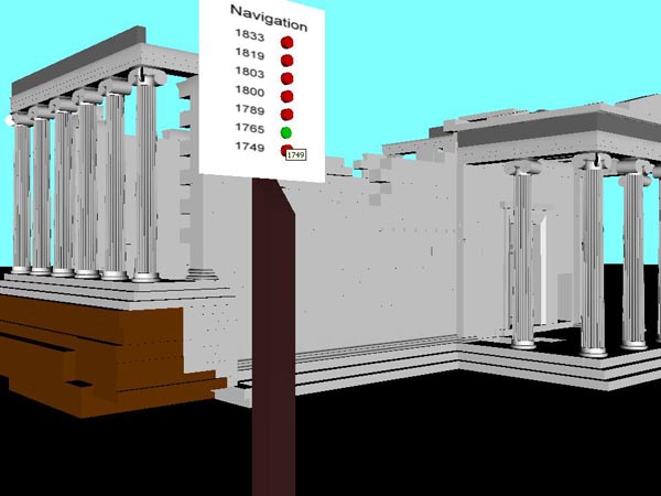
Fig. 9 – Erechtheion time machine control panel.
Given more resources, a more sophisticated interface could be created. With some of the more advanced features of VRML, users could "hop" through time from any location in the virtual-reality world by recording the position of the user and then "teleporting" them to the exact location and orientation in the new virtual-reality world. Alternatively, a single virtual-reality world could be created in which blocks in the building are activated or de-activated depending on which button on the time machine control panel is pressed.
6.2 Multiple user interaction and interactivity
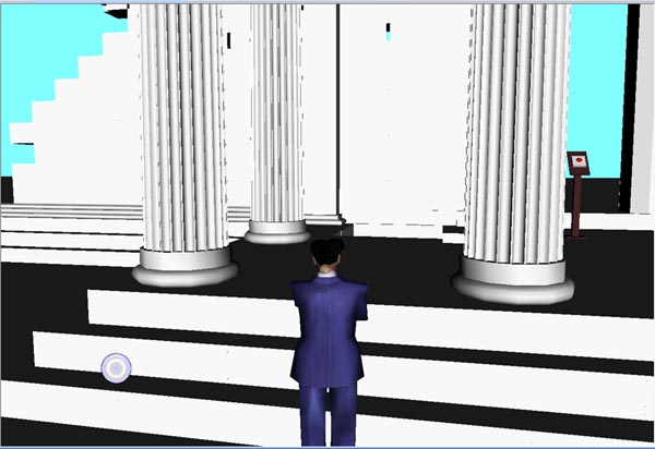
Fig. 10 – Erechtheion single-user environment.
By adding the reference to VRML World's frameset script, this is turned into a multi-user environment. This code, vrmlworld.net/frameset.php?url=http://www.erechtheion.org/CAD/ERE_web.wrl&title=Erechtheion, to activate this link will launch the Erechtheion in interactive mode as seen in figure 11.
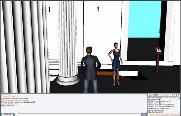
Fig. 11 – Erechtheion interactive mode.
Feel free to explore it and join other CSA Newsletter readers there. Please send us a message using the contact us button which you will find in the virtual-reality world.
This simple solution requires the VRML world to be posted on the internet where, in theory, anyone can interact with your research material. This may be the desired result of course, but if you wanted to implement this multi-user interactivity on your own server inside your project intranet, you could do so with ABNet server software from VRMLWorld.net.
We are still working on implementing the object database download part of the interactive 3D database in the interactive chat mode.
In this final article in the series on using AutoCAD to construct a 4D block-by-block model of the Erechtheion we have presented a method for constructing an interactive database whereby all manner of existing archaeological and architectural data can be presented in an intuitive and interactive manner. What is more, through its application on the Erechtheion we have shown that results can be achieved quickly, simply and cheaply using relatively minor extensions to existing, commonly-available tools.
We hope that the implementation of this technique on other research projects might improve the dialogue among those on the team and between the team and others. To aid with this, we are in the process of preparing a number of sample files, templates and instructions for others wishing to use the techniques we have described in the three articles in the series. In particular, we are preparing the Erechtheion VRML model with attached data for open public access. When they are ready, the files will be posted at www.erechtheion.org.
Once we have made them available, we will post a notification to the CSA Newsletter. Please feel free to contact us if you are interested in any aspect of this research or would like to collaborate on the application of these tools and techniques on your project.
-- Paul Blomerus and Alexandra Lesk
References
1. Lesk, Alexandra L. A Diachronic Examination of the Erechtheion and Its Reception, Ph.D. Thesis, University of Cincinnati, 2004. rave.ohiolink.edu/etdc/view?acc_num=ucin1108170608. Return to text.
2. We chose the VRML file format because it has been around for a long time, is an open format and can be viewed by anyone who downloads a choice of free viewing software. We recommend BS Contact by Bitmanagement Software as a VRML browser. There are other VRML browsers to choose from including Cortona3D Viewer by Parallel Graphics and some that provide Mac support (Octaga Player). All of these commercial products are available for instant download in free evaluation versions, but for those that prefer their software completely free and open source you can choose between FreeWRL and OpenVRML which support Mac OSX and Linux. Return to text.
3. We wish to thank Jiri Seda of Xanadu Software who kindly agreed to extend the evaluation licence for VRMLOut for free to enable this research. Return to text.
4. If you are not using Excel, you will find that many database programmes automatically output data to HTML file formats as a standard output option which will probably result in formatting which is much more pleasing to the eye. The only requirement is that the section of the file relevant to each object in the database starts with a bookmark named after the object ID. If the bookmarks is not inserted automatically, they can be added afterwards using the “find and replace” function of a text editor to augment the Object ID title of each data page with an HTML bookmark tag. Return to text.
5. Daniel Acevedo, Eileen Vote, David H. Laidlaw and Martha S. Joukowsky "Archaeological Data Visualization in VR: Analysis of Lamp Finds at the Great Temple of Petra, a Case Study," Proceedings of IEEE Visualization 2001. San Diego, California. October 2001. Return to text.
6. Jean-Charles Thomas, Gérard Subsol, Henry de Lumley, Véronique Pois, Bertrand Mafart, Jean-Pierre Jessel, Patrice Torguet. "3D Visualisation and Interaction with a Paleolithic Database. Workshop on Archaeology and Computers," Vienna (Austria), November 2004. Return to text.
7. "New Methodologies for the History of Cities: The City in Four Dimensions"("Nuove metodologie per la storia delle città: La città in quattro dimensioni") in Medieval Metropolises, Proceedings of the Congress of Atlas Working Group, edited by F. Bocchi, Bologna 1999, pp. 11-28. www.storiaeinformatica.it/nume/english/ntitolo_eng.html or www.learningsites.com/VWinAI/CINECA/VWAI_CINECA-BolognaVR.htm Return to text.
An index by subject for all CSA Newsletter issues may be found at csanet.org/newsletter/nlxref.html; included there are listings for articles concerning the use of electronic media in the humanities, articles concerning Applications of CAD modeling in archaeology and architectural history, and articles concerning Issues surrounding the use and design of databases.
Next Article: Yes, it is all about you: User Needs, Archaeology and Digital Data
Table of Contents for the April, 2009, issue of the CSA Newsletter (Vol. XXII, No. 1)
 Table of Contents for all CSA Newsletter issues on the Web
| CSA Home Page |